
Sucia
Island
The crown jewel of Washington’s marine parks: six distinct moorage areas, emerald coves, sculpted sandstone, abundant camping, and miles of unforgettable island trails.
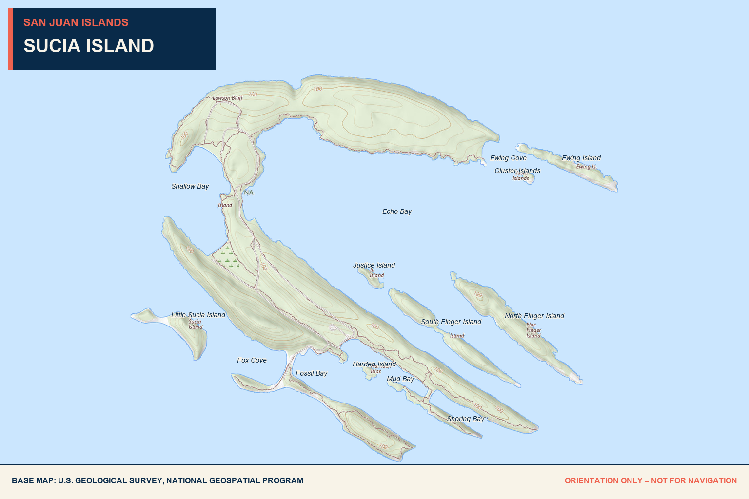
Echo Bay
14
Fourteen year-round Washington State Parks buoys are located in Echo Bay.
2 systems
Two linear moorage systems provide approximately 800 feet of moorage.
Largest area
Echo Bay is the island’s largest anchorage. Bottoms around Sucia are generally sandy mud, though eelgrass and seaweed can complicate setting.
Southeast winds
This broad bay is among Sucia’s most exposed moorage areas, particularly in southeast wind.
48°45′47.89″ N
122°54′37″ W.
Trails + camping
Landings connect to campsites, picnic areas, restrooms, seasonal water, and the island trail network.
No commercial services
No fuel, groceries, pumpout, garbage collection, or repair service is available.
Fees apply
Register and pay for buoy or linear moorage between 1 p.m. and 8 a.m. Boats rafted to another boat must also pay.
Roomy—
but exposed.
Its size can make Echo Bay feel forgiving, but southeast wind and traffic can create uncomfortable conditions. Inspect the set, maintain adequate swing room, and move before conditions deteriorate.
Ewing Cove
4
Four year-round park buoys are provided.
Available
Anchoring is permitted without a park fee. Confirm bottom, depth, swing room, and proximity to the buoys.
None
No public overnight dock is located in the cove.
48°45′55″ N
122°53′9″ W.
Chart carefully
Washington State Parks specifically cautions boaters to pay close attention at the Ewing Cove entrance.
Beach + trails
The cove provides access to beach exploration, camping areas, and island trails.
None
No fuel or pumpout service is available.
None
Bring food, water outside the seasonal supply period, and all other needed provisions.
Small cove.
Little margin.
Use current large-scale charts and a deliberate approach. Reefs and rocks surround Sucia, and constricted entrances can leave little room for improvisation.
Fossil Bay
16
Sixteen year-round park buoys make this Sucia’s largest buoy field.
2 docks
Two moorage docks provide approximately 640 linear feet. Dock 2 is removed from October through April to prevent winter storm damage.
Available
Anchoring is permitted without a park fee. Sandy mud is common, but eelgrass and seaweed can make setting difficult.
48°45′0″ N
122°54′1.98″ W.
Seasonal
Water is normally available from early April through September. Confirm the current park alert before relying on it.
Main facilities
Fossil Bay provides strong access to camping, restrooms, picnic areas, ranger contact, and the trail system.
None
No fuel, pumpout, garbage collection, or boat-repair services are provided.
Look—do not collect
Fossil collecting is strictly prohibited throughout Washington State Parks.
Outer buoys
feel the chop.
Outer buoys can receive more chop from weather and passing boats. In the colder season, verify dock availability before arrival. Select a buoy or berth appropriate to the forecast and vessel.
Fox Cove
4
Four year-round park buoys are provided.
Available
Anchoring is permitted, subject to room, bottom, weather, and the buoy field.
None
No public overnight dock is located in Fox Cove.
48°45′9.97″ N
122°54′47.88″ W.
Reef awareness
State Parks specifically advises frequent chart checks at the Fox Cove entrance.
Trails nearby
Landing provides access toward Fossil Bay, Little Sucia viewpoints, camping, and the trail network.
None
No fuel or pumpout service is available.
None
No groceries, dining, or commercial services are available.
Confirm the
entrance visually.
Do not cut corners around the cove or Little Sucia Island. A long reef extends west of Little Sucia, and local rocks demand careful chart work.
Shallow Bay
8
Eight year-round park buoys are provided.
Available
Anchoring is permitted. Assess charted depth carefully—the bay’s name is useful advice.
Except west
The bay is protected from many directions but remains exposed to westerly wind and waves.
48°45′43.92″ N
122°55′2″ W.
Three sides
The bay offers multiple beaches, including a sandy beach to the north and a central pebble landing serving camping and moorage payment.
Seasonal
Water has traditionally been available May through September. Confirm the current park alert.
None
No marine fuel or pumpout service is available.
Chart carefully
State Parks specifically cautions boaters to pay close attention at the Shallow Bay entrance.
Beautiful—
until it blows west.
Westerly wind and sea can make Shallow Bay uncomfortable or unsafe. Check the forecast before committing, and maintain an exit plan.
Snoring Bay
2
Two year-round park buoys are provided.
Available
Anchoring is permitted where room and conditions allow.
None
No public overnight dock is located in the bay.
48°44′55.67″ N
122°53′26.99″ W.
Reefs extend out
Reefs extend from Ev Henry Point and the finger islands. Use current charts and avoid shortcutting the approach.
Trails + beach
The bay connects to island trails and the south-shore sandstone landscape.
None
No marine services are available.
Not at the bay
Carry water or obtain it from an operating seasonal park source elsewhere on the island.
Two buoys.
Reefs nearby.
Capacity is limited and surrounding reefs reduce the margin for error. Have another Sucia anchorage selected before arrival.
The crown jewel.
A must-see.
Sucia Island Marine State Park is an approximately 814-acre, boat-access-only park with roughly 77,700 feet of shoreline. The main island and surrounding islets form the horseshoe-shaped Sucia group.
The magic is ashore as much as afloat: roughly ten miles of trails connect remarkable bays, beaches, forest, viewpoints, campsites, and weathered sandstone formations.
There are 60 primitive campsites, including four reservable group camps. Potable water is seasonal, there is no garbage service, and visitors should pack out everything they bring.
Island-wide hazards
Clements Reef, the reef west of Little Sucia, reefs off Ev Henry Point, the Finger Islands, and the Cluster Islands all demand careful chart work. Use current charts rather than the guide map for navigation.
Sandstone + geology
Sucia’s folded and eroded rocks create its dramatic horseshoe form, honeycomb weathering, sculpted cliffs, and pocket coves.
Washington’s dinosaur
A fragment of theropod femur discovered on Sucia became Washington’s first recognized dinosaur fossil. Fossil and natural-resource collecting is prohibited.
History
Sucia lies within the traditional territory of Coast Salish peoples. Spanish explorer Francisco de Eliza charted “Isla Sucia” in 1791; the name is commonly interpreted as “dirty” or “foul” in a nautical sense, likely reflecting difficult waters.
Aug 2021
Lovely hikes.
Extraordinary bays.
We stayed in Fossil Bay in August 2021. The outermost buoys received more chop from weather and passing boats, but the views were beautiful and the wildlife and unusual rock formations made the visit memorable.
We especially enjoyed hiking between the bays. The viewpoint where you can look through from Fossil Bay toward Fox Cove is distinctive, and traveling by dinghy made it possible to explore places we did not feel comfortable approaching with the larger boat because of shallow rocks.
There were no provisions, but primitive toilets and seasonal water were available. Sucia is one of those rare destinations where the shore experience is as important as the moorage—it is a must-see.
Send updated local intel →This is a dated firsthand record. Buoy availability, docks, water, camping, fees, fire restrictions, park alerts, and boating conditions can change; confirm directly and use current nautical charts.
Sucia Island
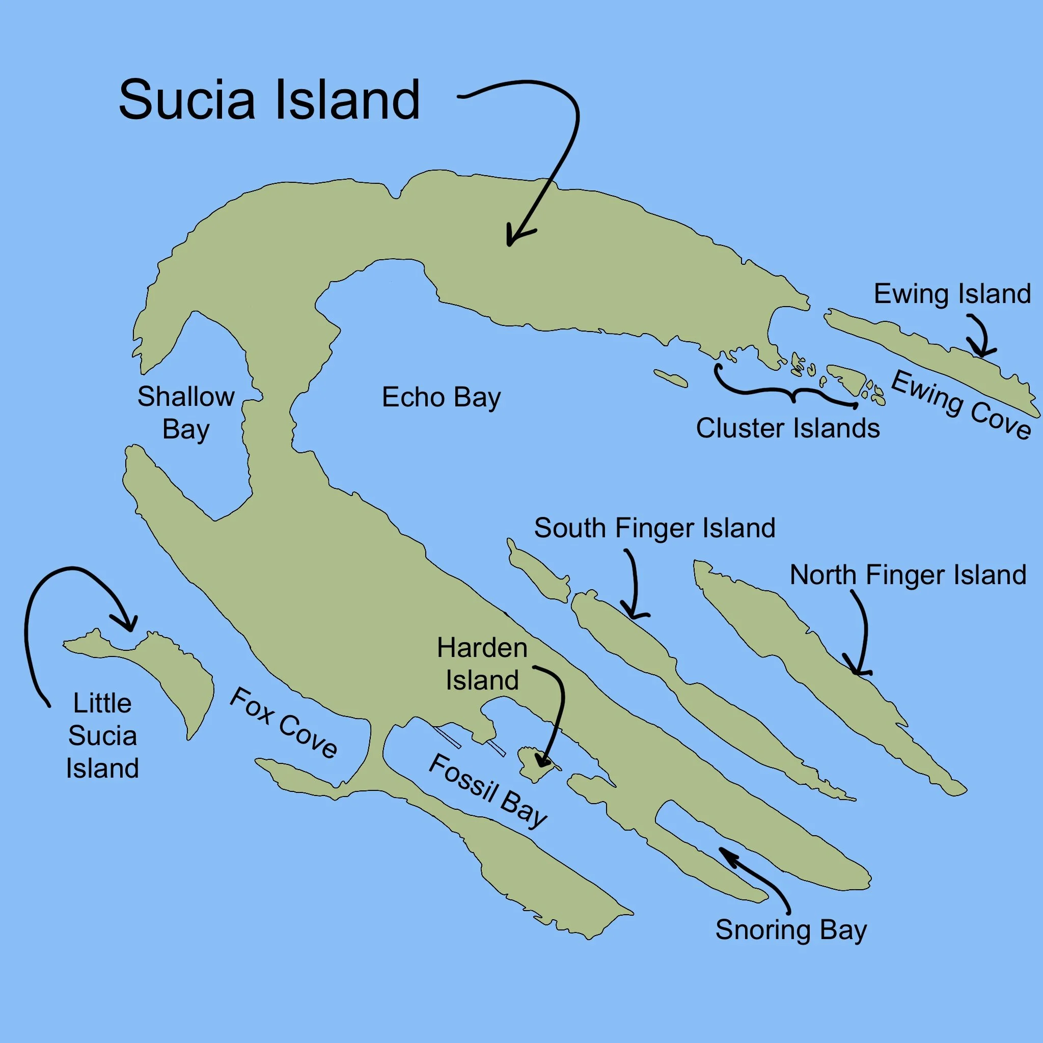
ECHO BAY
14 buoys
2 linear moorage systems (800 linear feet).
This is the largest of the anchorages, and the most exposed, particularly to southeast winds.
Latitude: 48 45' 47.89" N (48.7633) Longitude: 122 54' 37" W (-122.9102)
EWING COVE
4 buoys.
Latitude: 48 45' 55" N (48.7652) Longitude: 122 53' 9" W (-122.8858)
FOSSIL BAY
16 Buoys
2 Moorage docks (640 linear feet) One dock is removed from late October through March to prevent winter storm damage.
Fossil Bay has potable water
Latitude: 48 45' 0" N (48.75) Longitude: 122 54' 1.98" W (-122.9005)
FOX COVE
4 buoys.
Latitude: 48 45' 9.97" N (48.7527) Longitude: 122 54' 47.88" W (-122.9133)
SHALLOW BAY
8 buoys.
It is protected from all but westerly winds and waves.
One of the northern most of the San Juan Islands, often called the Crown Jewel of the San Juan Islands.
Sucia Island Marine State Park is an 814-acre marine park with 77,700 feet of shoreline and abundant camping and moorage. The main island and several smaller islands comprise the "Sucia group." There are no services on this island, and fossil collecting is strictly prohibited in this and all Washington state parks. 10 miles of hiking trails.
Boaters should use caution when in the waters around this park. The word "sucia" is Spanish, meaning foul or dirty in a nautical sense. It refers to the numerous rocks and reefs which surround the island. These rocks and reefs have grounded and sunk numerous boats since European explorers first named the island in the 1790s. Boaters should check their charts frequently and pay particular attention to Clements Reef on the north shore of Sucia, as well as the entrances to Ewing Cove, Fox Cove, and Shallow Bay. There is a long reef which extends to the west of Little Sucia Island. Reefs also extend outward from Ev Henry Point, North and South Finger islands, and the Cluster Islands.
*No provisions available at these locations
Baller Verified
OG Baller:
We have stayed at Fossil bay 8/2021
While the outmost buoys get more chop from weather and passing boats, the views are quite lovely. We enjoyed hiking and watching some of the wildlife. The unique rock formations are something to see. The spot where you can stand and see thru from Fossil bay to Fox bay is a unique place. It was fun take the dingy and go around to the different bays and explore a few of the places we didn’t feel comfortable going with the boat due to concerns for the shallow rocks. It was a cool way to see the Lacey rocks
There are no provisions at this location
There are primitive toilets and some water available


