
San Juan
Island
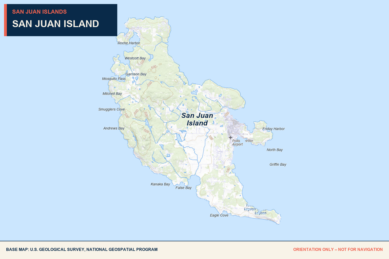
The islands’ busiest population center, with two major destination marinas, broad town services, historic shore access, shellfish, and several useful anchoring areas.
Friday Harbor
500 slips
Friday Harbor Marina has approximately 500 slips, with about 100 available for overnight visitors.
20–70 foot slips
Designated slips serve vessels from roughly 20 to 70 feet; larger boats may use floating concrete breakwater side ties.
Channel 66A
Hail the marina when in sight of the harbor for a slip assignment.
360-378-2688
Visit Friday Harbor Marina for reservations and current operating details.
Fuel pier + utilities
Fuel, potable water, shore power, Wi-Fi, laundry, restrooms, and showers are available.
Year-round
Stationary, portable, and pumpout-boat sewage services are listed.
Walk to services
Food markets, restaurants, hardware, lodging, galleries, theaters, and other provisions are directly uphill from the marina.
Ferries + seaplanes
Expect Washington State Ferry movements, passenger traffic, commercial activity, and scheduled seaplanes around the harbor.
Ferries.
Seaplanes.
Commercial traffic.
Friday Harbor is convenient but active. Monitor VHF traffic, maintain awareness near the ferry terminal and seaplane operating area, and wait for a marina assignment before entering tight fairways.
Roche Harbor
425 slips
Roche Harbor is a large year-round destination marina serving transient, seasonal, and group moorage.
200'+
The marina lists accommodation for vessels over 200 feet.
Channel 78A
Hail the harbormaster when arriving. Peak-period waitlist requests are also handled on VHF 78A.
800-586-3590
Visit Roche Harbor Marina for current availability, rates, and reservation requests.
Power + water
30-, 50-, and 100-amp power, water hookups, garbage service, Wi-Fi, showers, and laundry are available.
Full service
The fuel dock carries diesel and ethanol-free unleaded. Mobile pumpout service is available.
Market + dining
Three waterfront restaurants, a large market, lodging, an outdoor pool, and other resort services are within the harbor.
Floatplane dock
Scheduled floatplane activity uses the harbor. Remain alert to aircraft operations.
Nightly colors.
Peak demand.
The nightly colors ceremony occurs about 20 minutes before sunset from early May through late September. Summer and holiday demand is high; reservations are strongly recommended, and July Fourth space is especially limited.
Westcott Bay
Westcott Bay Shellfish
The bay is home to a working shellfish farm and seasonal dining destination. Reservations are recommended.
None
No public mooring buoys are listed for Westcott Bay.
Assess locally
Select any anchoring position only after reviewing current charts, depth, bottom, swing room, and private shoreline boundaries.
Confirm before landing
Coordinate directly with the shellfish farm or other destination before relying on dock or shore access.
Limited / seasonal
Food service and retail are destination-specific and seasonal rather than general marina provisions.
None
Use Roche Harbor or Friday Harbor for full marine services.
Respect operations
Keep clear of aquaculture gear and working areas.
Reserve + confirm
Check current farm hours, dining reservations, and landing instructions.
Garrison Bay
Mud bottom
The sheltered bay’s muddy bottom is commonly used for overnight anchoring.
None
No public mooring buoys are provided.
20 feet maximum
English Camp permits vessels up to 20 feet at the dinghy dock for no more than four hours in a 24-hour period.
Use the dock
The dinghy dock is the only permitted watercraft landing or launch point within the English Camp unit.
English Camp
The landing provides access to the historic parade ground, trails, cemetery, blockhouse, and other park resources.
Check advisories
Harvest may be allowed north of the dock. Confirm health advisories, seasons, licenses, and limits first.
Nighttime interest
Garrison Bay is known for occasional bioluminescent algae displays.
Do not land on Guss
Guss Island is closed to public access and watercraft landings are prohibited.
Land only
at the dock.
Do not beach dinghies or kayaks along the English Camp parade-ground shoreline. Follow the vessel length and four-hour time limits at the designated dock.
Fourth of July Beach
Good conditions reported
The Griffin Bay shoreline off Fourth of July Beach is used as an anchoring area. Confirm holding and exposure on arrival.
None
No public mooring buoys are provided.
Pebble shoreline
The National Park Service provides public beach access, picnic space, and a kayak launch.
Strong currents
The waters are more sheltered than South Beach, but swimming is discouraged because of current.
Not allowed
Fires are prohibited at Fourth of July Beach.
Restroom + trash
The beach area includes a restroom and trash facilities.
Old Town Lagoon
A shoreline route connects toward Old Town Lagoon and the historic San Juan Town site.
None
Use Friday Harbor or Roche Harbor for full marine services.
Current still matters.
A relatively sheltered shoreline does not remove current, weather, depth, or holding concerns. Use current charts and assess conditions before anchoring or landing.
Busy ports.
Deep history.
San Juan Island is the archipelago’s second-largest island and its most populated, with 8,632 residents recorded in the 2020 census. Friday Harbor and Roche Harbor are its two principal boating centers.
Friday Harbor provides the broadest walkable concentration of groceries, restaurants, coffee, lodging, shopping, transportation, and marine services. Roche Harbor combines a major marina with resort dining, shopping, lodging, events, and traditions.
Friday Harbor provisions
King’s Market is a short uphill walk from the marina. Numerous restaurants, cafés, coffee shops, bars, and takeout options surround the waterfront and town center; confirm current hours directly.
Roche Harbor provisions
The Company Store and other resort retailers provide groceries, wine, supplies, gifts, apparel, and services. Waterfront restaurants and cafés operate seasonally or year-round on varying schedules.
Transportation
Friday Harbor is the Washington State Ferry terminal and supports scheduled seaplane activity. Roche Harbor also has floatplane access.
Historical shoreline
English Camp and American Camp preserve landscapes central to Coast Salish history and the peaceful joint British-American occupation associated with the Pig War era.
Yearly
A lively island.
A summer must.
We visit San Juan Island yearly. Friday Harbor is a great first stop when arriving from Seattle, with the islands’ largest concentration of dining and the Washington State Ferry terminal directly in town.
We have also spent many trips at Roche Harbor, both staying in the marina and on land. San Juan Island feels like the liveliest of the islands, and we consider it a must-stay each summer.
For July Fourth, Roche Harbor puts on a memorable fireworks show. Another favorite is the nightly colors ceremony at Roche Harbor during its summer season.
Send updated local intel →This record reflects recurring firsthand visits. Marina availability, restaurant hours, events, ferry schedules, marine services, fees, and access can change; confirm directly and use current nautical charts.